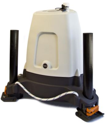
ZephIR 300 - Onshore Wind Lidar
Continuous wave wind lidar

ZephIR 300: Hub height wind measurements reduce the risk of, and increase the value of onshore wind energy projects.
Onshore wind lidar measurements typically deliver a £320,000 increase on the value of a project through more accurate Annual Energy Prediction (AEP) when compared to a 80m met mast on a 20 MW onshore wind farm – The Ecofys position on LiDAR use.
ZephIR 300 wind lidar is used extensively through the pre-planning / scoping, planning, development, construction and operational phases of an onshore wind energy project in combination with short met masts and tall met masts and associated cup anemometers, roaming during site-prospecting, stand-alone in replacement of a met mast and as a fixed reference control mast.
ZephIR Lidar applies more than a decade of experience in wind energy to ensure ZephIR 300 and ZephIR DM wind lidars can be utilised effectively at every stage of your wind energy project – from pre-planning through to re-powering – both onshore and offshore.
Product Features
- Remote Wind Profiling across 10 user-defined heights from 10 metres (33 feet) to 200 metres (656 feet)
- Unparalled Experience bourne across 750+ deployment, 7 million hours of operation and a decade of wind lidar experience globally
- Finance-Grade Wind Data accepted by Banks’ Engineers as part of the formal energy assessment of a wind project (DNV GL Stage 3 lidar)
- Proven Extreme Operation from -40°C to +50°C across more than 650 lidar deployments globally
- Technical Support with local service engineers across Europe, North America, South America and Asia Pacific
- Industry Approved Validations including IEC equivalent power performance measurements, extensive onshore / offshore campaigns and tall met mast verifications
Data from ZephIR lidar can be uploaded to the AmmonitOR online platform to be monitored and analysed

Pre-Planning
- Research / Academia – Wind profiling, turbine experiments, calibration of wind sensors, bespoke lidar configurations
- Complement to Met Mast – From low 10 metre (33ft) masts up to world-class 200 metre (656ft) research masts
- Wind Shear Verification – Across the entire turbine rotor diameter including measurements above and below down to just 10 metres (33ft)
- Turbulence
Planning
- Wind Resource Assessment, Site Classification and Micro-Siting – Accurate siting of wind turbines for optimised energy production
- Wind Model Verification – In-situ measurements to verify and adjust wind models such as WASP® and VENTOS®
- Fixed Reference / Long Term – A continuous data set across measurement heights ranging 10 metres (33ft) to 200 metres (656ft)
- Wind Shear Verification – Across the entire turbine rotor diameter including measurements above and below down to just 10 metres (33ft)
- Complement to Met Mast – From low 10 metre (33ft) masts up to world-class 200 metre (656ft) research masts
- Research / Academia – Wind profiling, turbine experiments, calibration of wind sensors, bespoke lidar configurations
- Turbulence
Construction/Finance
- Safe operation – Real-time wind speed measurements at hub height during WTG component lifting and assembly
- Energy Yield Analysis – Finance-grade wind data for the purpose of Energy Yield reporting and analysis
- Complement to Met Mast – From low 10 metre (33ft) masts up to world-class 200 metre (656ft) research masts
- Fixed Reference / Long Term – A continuous data set across measurement heights ranging 10 metres (33ft) to 200 metres (656ft)
- Research / Academia – Wind profiling, turbine experiments, calibration of wind sensors, bespoke lidar configurations
- Turbulence
Operation
- WTG Condition Monitoring – Nacelle-mounted measurements to monitor condition of WTG against measured wind speed and for performance trouble shooting
- Power Performance Testing & Performance Optimisation – Nacelle-mounted and / or ground based measurements to monitor performance of WTG against measured wind speed
- Wind Model Verification – In-situ measurements to verify and adjust wind models
- Complement to Met Mast – From low 10 metre (33ft) masts up to world-class 200 metre (656ft) research masts
- Fixed Reference / Long Term – A continuous data set across measurement heights ranging 10 metres (33ft) to 200 metres (656ft)
- Forecasting – Real-time wind measurements to support site energy forecasting
- Research / Academia – Wind profiling, turbine experiments, calibration of wind sensors, bespoke lidar configurations
- Turbulence
Re-Powering
- WTG Condition Monitoring – Nacelle-mounted measurements to monitor condition of WTG against measured wind speed and for performance trouble shooting
- Power Performance Testing & Performance Optimisation – Nacelle-mounted and / or ground based measurements to monitor performance of WTG against measured wind speed
- Wind Model Verification – In-situ measurements to verify and adjust wind models
- Complement to Met Mast – From low 10 metre (33ft) masts up to world-class 200 metre (656ft) research masts
- Fixed Reference / Long Term – A continuous data set across measurement heights ranging 10 metres (33ft) to 200 metres (656ft)
- Forecasting – Real-time wind measurements to support site energy forecasting
- Research / Academia – Wind profiling, turbine experiments, calibration of wind sensors, bespoke lidar configurations
- Turbulence
| Performance | ZephIR 300 |
|---|---|
| Range (min.) Range (max.) |
10 metres 200 metres |
| Probe length @ 10 m Probe length @ 100 m |
± 0.07 metres ± 7.70 metres |
| Heights measured | 10 (user-configurable) |
| Sampling rate | 50Hz |
| Averaging period | user configurable (1 second as standard) |
| Scanning cone angle | 30° (other angles available) |
| Speed accuracy variation* | < 0.5% |
| Speed range | < 1 m/s to 70 m/s |
| Direction accuracy variation* | < 0.5° |
| Data Heading | Unit | Explanation |
|---|---|---|
| Reference | - | Numerical reference of each record |
| Time and date | - | In text format, to the nearest second |
| Timestamp | Seconds | Time and date of the reading as numerical value in seconds |
| Horizontal wind speed | Metres per second | Horizontal wind speed measured by ZephIR |
| Vertical wind speed | Metres per second | Vertical wind speed measured by ZephIR |
| Horizontal wind direction | Degrees | Horizontal wind direction measured by ZephIR |
| Horizontal min / max | Metres per second | Minimum / maximum horizontal wind speeds measured by ZephIR |
| TI | - | Turbulence Intensity |
| Generator | Volts | External supply voltage, if present |
| Upper temp / lower temp | Degrees Celsius | Pod temperature |
| Pod humidity | Percent | Internal ZephIR humidity |
| GPS | Decimal Degrees |
GPS location (lat and long) |
| ZephIR bearing | Degrees | Direction of the ZephIR wrt True North |
| Tilt | Degrees | Pitch and roll away from vertical |
| Air Temp. | Degrees Celsius | Ambient temperature |
| Pressure | Millibar / Hectopascals | Ambient pressure |
| Humidity | Percent | Ambient humidity |
| MET wind speed | Metres per second | Horizontal wind speed measured by the MET station |
| MET direction | Degrees | Wind direction measurement by the MET station |
| Raining | - | Rain sensor detects rain |
| Data | ZephIR 300 |
|---|---|
| 10 minute averaging | 90Kb / day |
| 1 second data | 3MB / day |
| On board storage | 36 months |
| Data transfer | LAN; MODBUS; WiFi; Global SIM; Iridium Sat Comms |
| Timestamp / Location | GPS |
| Safety | ZephIR 300 |
|---|---|
| Laser classification | Class 1 |
| Eye safety standard | IEC 60825-1 |
| IP Rating | IP67 |
| Compliance | Full CE accreditation |
* As measured against a calibrated moving target.
** In off-grid, DC power situations, excluding any convertor losses and in standard climates.
Always refer to manufacturers guidelines on power before specifying 3rd party power solutions.


