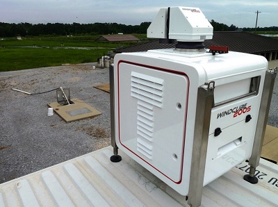
WINDCUBE 100S/200S/400S
3D Long range Wind Doppler LIDAR

The WINDCUBE 3D LIDAR product range is a versatile instrument that can address various needs in the Wind Power, climate research, severe weather and meteorology. With a range from 100m to 3.5 km, 6 km or 10km, multiple scanning patterns choices, high resolution wind data and aerosol structure capability, the WINDCUBE 100S/200S/400S is the ultimate 3D Doppler LIDAR in the industry.
FOR WIND POWER
Scanning wind Doppler LIDARs systems offer a fully integrated operational capacity to improve wind measurement at any stage of a wind farm project, from prospection to operation. WINDCUBE 100S / 200S / 400S perform a full 3D mapping of the atmosphere to provide enhanced measurements of wind speed and direction.
Key Benefits
- Wind measurement to 10 km
- Unattended and continuous operations
- Ideal for short term campaigns
- Full 3D fast scan
- Flexible configurations
FOR WEATHER & CLIMATE
The WINDCUBE 3D scanning Wind Doppler LIDAR system is a versatile tool for recovering highly accurate, real-time wind measurements in any scanning geometries up to 10km within the planetary boundary layer (PBL). Its optional integrated structure detection algorithm also gives it the capability of detecting the presence of clouds or aerosol layers in the troposphere.
Key Benefits
- Automatic 3D cloud/aerosol detection
- Reliable, unsupervised operation
- Fast deployment and setup
- Versatile instrument configuration
For more details on applications, please, see brochures under the Documentation tab.


